
The Steens Loop is formed by two roads, north and south, both traveling east from different points of the Hwy 205 and completing the loop by connecting in the summit area of the mountain. The north access road to the Steens Mountain summit starts in Frenchglen. For the south access road you continue south from Frenchglen on Hwy 205 for a few miles.

Frenchglen
Last time I was here, in 2010, the south road was a bit on the rough side of things: rocky, and at some points it was narrow with some ruts added to the mix. It was lots of fun chasing Doug on the way down that mountain on the south road. And the north road was a gravel highway, very well graded, with small “ball-bearing” type of gravel, good enough for any motorcycle or car to comfortably get to the top of the mountain. With the WR250R my choice was to go up the mountain on the south road. If it was fun coming down on that road, it should only be better going up that road.

Frenchglen Mercantile, August 31st, 2013
The plan was to go to the top of the mountain, visit the regular overlook sites, then explore some of the smaller, two-track, and unimproved side roads branching out of the main roads.
After a great breakfast, thank you Annie, we got on our way to Frenchglen for fuel. And from there Doug and Annie took the north road for an easy and quick way up. Christian and I got on 205 south towards the south access road.

Sign at the entrance on the south access road
The first portion of the south road, before reaching the mountain itself, was all nicely graded, like it was already back in 2010, with the same ball-bearing gravel as the north road. After a few miles on that road you get a clear view of the mountain.
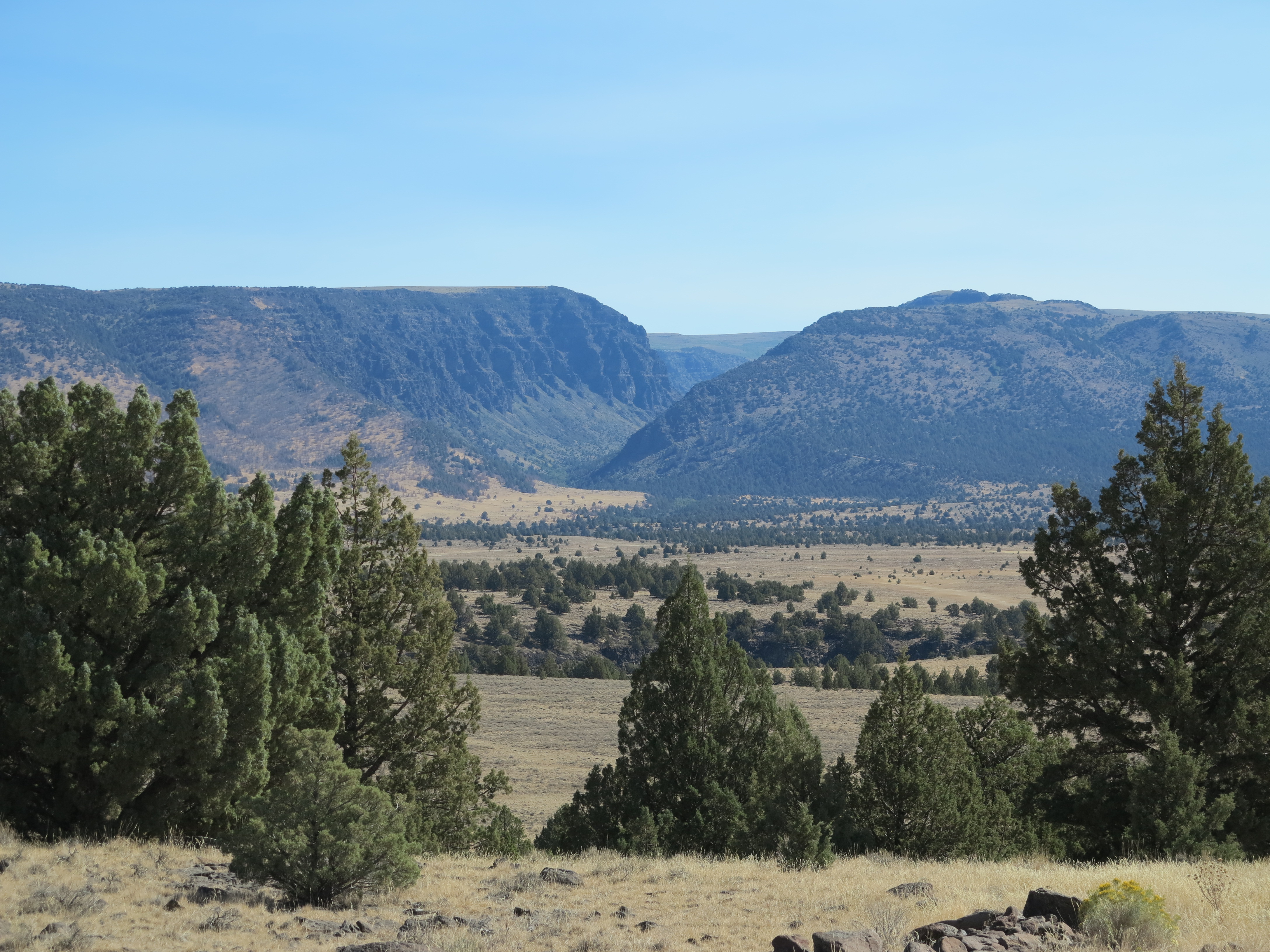
The Steens Mountain, a view from the south access road
And then we start the climb itself, where the fun would start. However, the former rocky road I was looking forward to riding was nowhere to be found. That road has been graded and graveled all the way to the top since the last time I was there.

Christian enjoying the climb
We made a few stops here and there to check the views.

Big Indian Gorge
The south road climbs on the north side of the Big Indian Gorge, one of the canyons originated from the mountain. The climb was more dramatic when the road was less improved. It gave the feeling someone could relate, with good imagination, to what I’ve seen on photos and video footage of the famous death road in Colombia. Minus the traffic, of course. But now it is a smooth and easy ride all the way to the top, although you still have a chance to ride close to the edge of the mountain, and with no guard rail.
And then it reaches a plateau between two canyons, the Big Indian Gorge and the Little Blitzen Gorge.

The plateau, and the Big Indian Gorge on the right
On the plateau you get the impression you are riding on top of the world. Thanks to Christian, I get to be photographed in action on this trip. Christian stops for pictures, has a nice camera and a great eye for great shots – I will share some of his shots along the way. The Little Blitzen Gorge is on the left on the photo below.

That’s me, riding the south access road on my way to the top of the Steens Mountain – photo Christian Abächerli
And this is what the road looks like when viewed from the top, between the two canyons. You can see, way back there, how the south road goes down on the side of the Big Indian Gorge, going towards the left before disappearing from view.

Looking west from the top of the Steens Mountain. A gravel road snakes down from the mountain. August 31st, 2013
And here is a short video of the climb, and then reaching the other road on the top. You can see how close the road gets to the edge. Please adjust video quality to 720HD for a better image.
We met Doug and Annie on the top, they had arrived a few minutes earlier and had already done some investigation and suggested a route and stops.

Deciding where to go next.
We decided to first check the East Rim overlook, which is just ahead from where the photo above was taken, then check the summit, the Kiger Gorge view point, Fish Lake, then try some of the side roads, and go back down to the camp on the north access road of the Steens Loop.
From the East Rim overlook, here is the northeast area, towards Idaho.

Looking to the northeast
Looking east and to the south, you can see the Alvord lake, the playa, and the desert. Probably Nevada in the background.

Sometimes in June the lake has actual water, something like a foot of water
Next we went to the Summit. Doug had noticed earlier the gate to the summit was open. Cellular companies have built towers on top of the Steens, AT&T reception was perfect. But access to the summit is now limited.

The very summit of the Steens Mountain
Since the cell tower crew was working on the area, they had the gate open, unwillingly allowing us access to the summit. They told us they would be leaving soon, and we should leave before they did, they were going to close and lock the gate on their way out.

Dangerous job, actually the most dangerous occupation in the US
I had heard of accidents with people working on cell towers just recently – this type of work has been rated the most dangerous job in America, more dangerous than working on a crab boat in Alaska. I talked to the crew and of course, they were very aware of these reported accidents. They had all the safety gear on.
I had never been to the summit before. It is a very steep incline to get there, and no cars were there except from the crew’s truck.

Chris riding to the summit
And of course, our motorcycles with their “special access” granted by first doing it and explaining it later if needed (and asking for forgiveness if it turned not to be okay). But as I mentioned, they were nonchalant about us being there, just asked we left before they did.

The three bikes on the top. Annie decided to hike to the top instead of riding
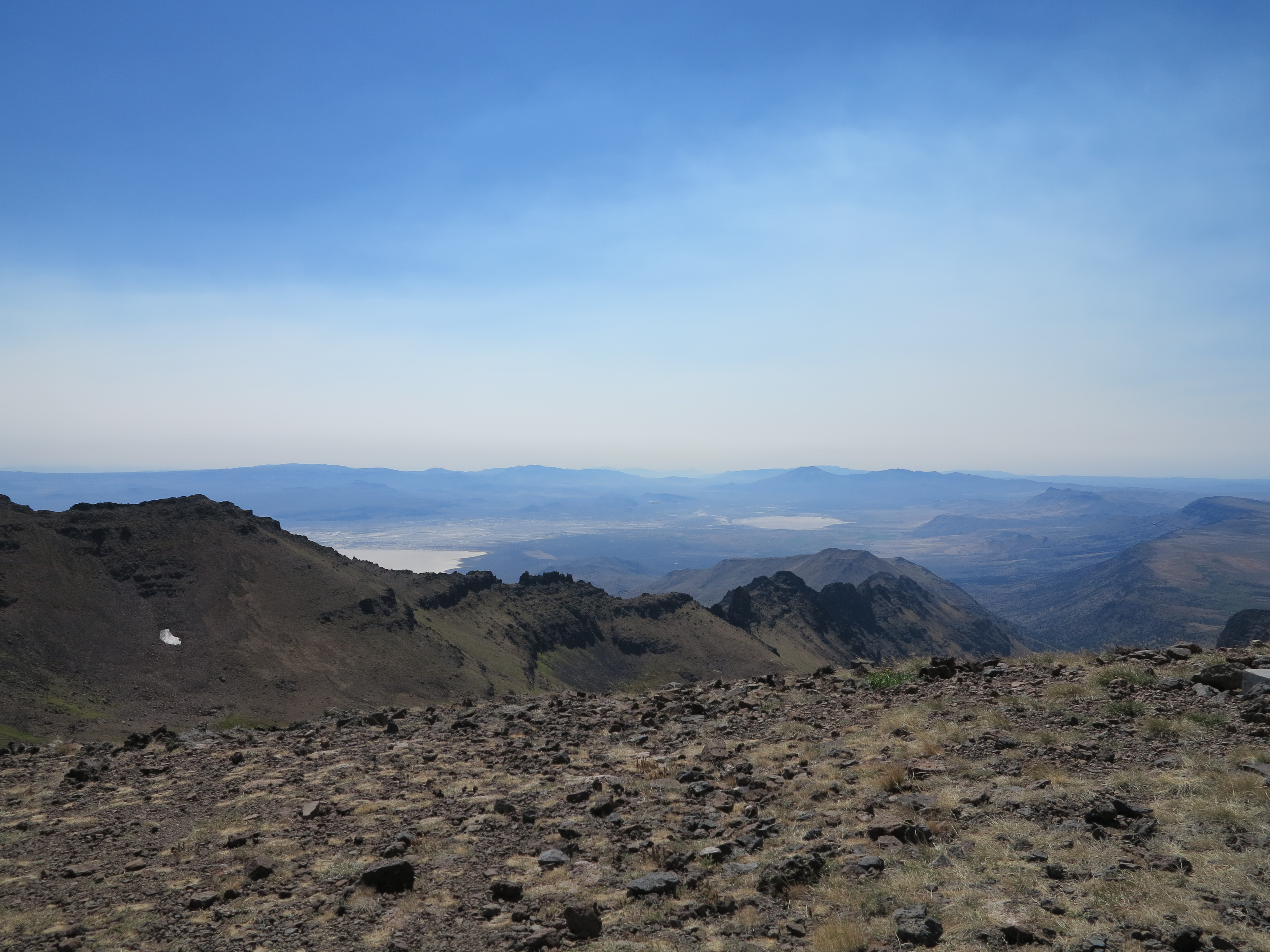
Of course, from the summit you get all kinds of views. To the southwest, you see Wildhorse Lake and beyond.

Wildhorse Lake and beyond towards Nevada
To the south east you see the playas south of the Alvord Desert. That one white spec on the side of the mountain is left over snow from last winter. When I was here in September of 2010, there was a lot more snow. This year we only saw traces of snow here and there, a result of the dry winter we had this year. Actually, in 2010 when we were here there was fresh snow on the ground when rode the East Rim overlook area.
Looking towards the south east, towards Nevada
Looking east, Idaho is there at some point in the not so distant horizon.

Looking to the east, towards Idaho.
Anyway, lets talk about the WR250R, what a nice little motorcycle it is. All along this ride I was wondering what a larger motorcycle could do on these roads. Chris’ F800GS did very well on this trip, a really impressive motorcycle. It can’t go as fast the WR250R does on some of these narrow and rough roads. I can throw the WR250R into these roads without worrying much, it is light, easy to handle if needed. But I just wonder… and I think about my Tiger800XC, and while I know it can travel these roads, my question is always about the fun factor: will the 800XC be as much fun as the WR250R? I doubt it. But I know if I had at least some 10-15 extra HP in the WR’s motor it would be a lot more fun.
I’m thinking… and wishing Honda, which is finally snapping out of its doldrums, would go one step further and make a version of its sweet CRF450 Rally bike available to the public. I even thought about that CB500X. The Honda Racing Team, in its Thai chapter, has made a nice version of that bike, adding a 21 inch front wheel and the CRF250 front end and upgrading its rear spring/shock and adding an 18 in wheel in the rear. It looks nice, and its twin cylinders should provide good road action. And it could be a lot of fun on these roads. And I always liked the F800GS, although it is almost as heavy as my Tiger.

The WR250R on the top of the mountain, August 31st, 2013
But for now, the WR250R does the job well. I was the last one out of the summit. I videoed the descent, I don’t think I ever took it out of first gear. In the video you can not see how steep this road is at times, but take my word for it, at some points, it is steep. You will notice when I slowed down right before I went past Doug and Annie that were hiking up to the summit and the tires are barely holding traction. I did not venture getting my hand off the handlebars to wave at Doug and Annie.
From the summit we went to Kiger Gorge, another nice area to enjoy the vistas from the Mountain.

Kiger Gorge, August 31st, 2013
We had lunch there, Doug and Annie had brought bread, cheese, salami, it was just perfect!

Nice chat after lunch
From here we started down on the north road of the Steens Loop and eventually turned off the main road to take a look at the Fish Lake.

Doug going down on the north road of the Steens Loop
Fish Lake.
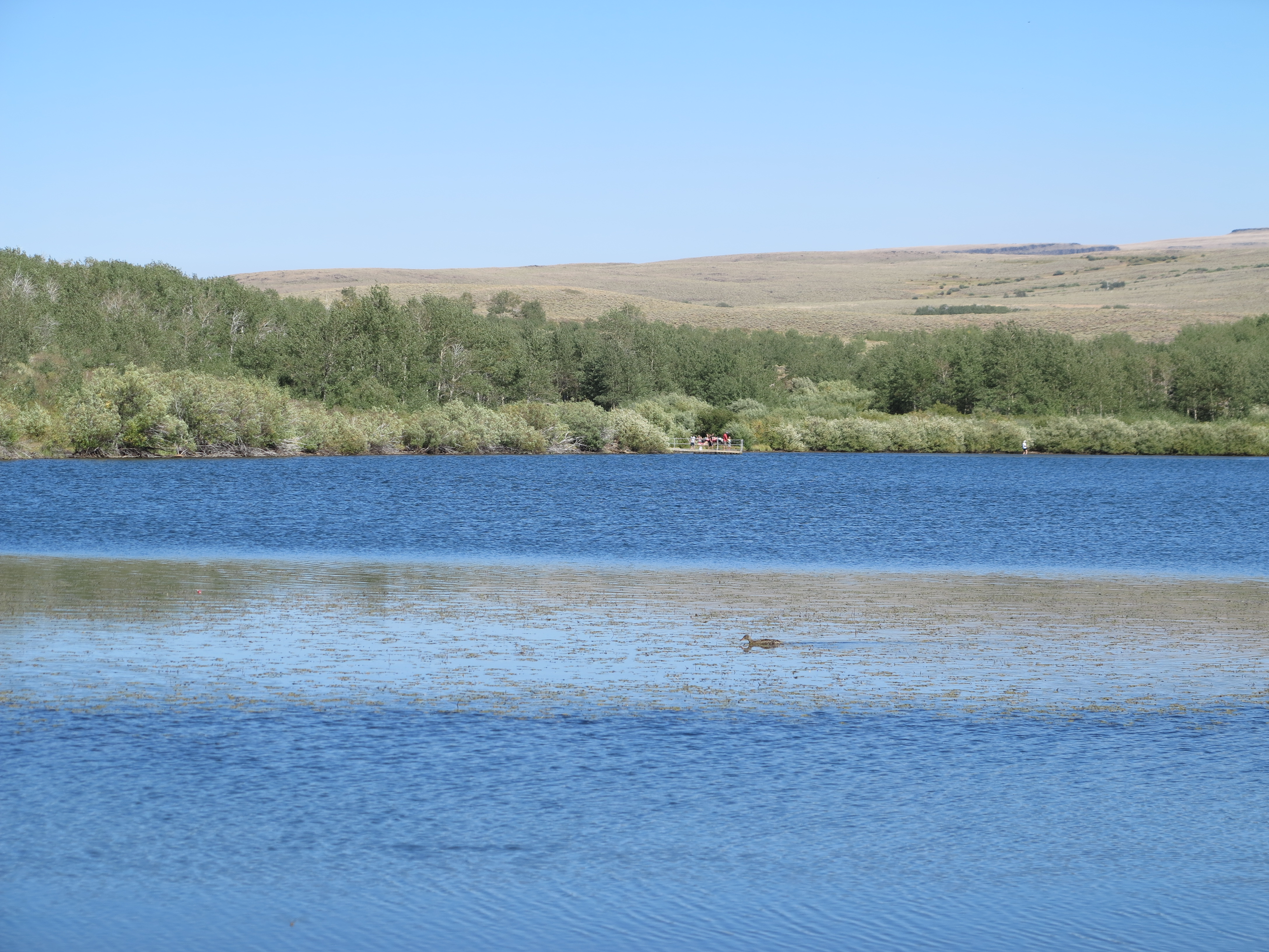
Fish Lake
From Fish Lake, Annie went back to Kiger Gorge to sketch the Kiger Gorge on water colors. And we took one of those side roads I was talking about. Doug had heard there was, some time ago, many years ago, a hunters’ lodge or cabin somewhere in the mountain. Not only that, but he had heard if we went past the cabin we would find vistas to one of the canyons coming from the west side of the Steens Mountain, the Little Blitzen Gorge. Very few people have a chance to see the views that were promised to us.
The road was really unimproved, lots of ruts, real ruts, off camber, two tracks, lots of rocks here and there, some rather large. We made it to the cabin, or lodge as some refer to. I was really impressed by the F800GS and Chris’s riding, they made it through all of this without a hitch.

The Hunters’ Lodge
There isn’t much left of the lodge.

Barely standing
It is barely standing.
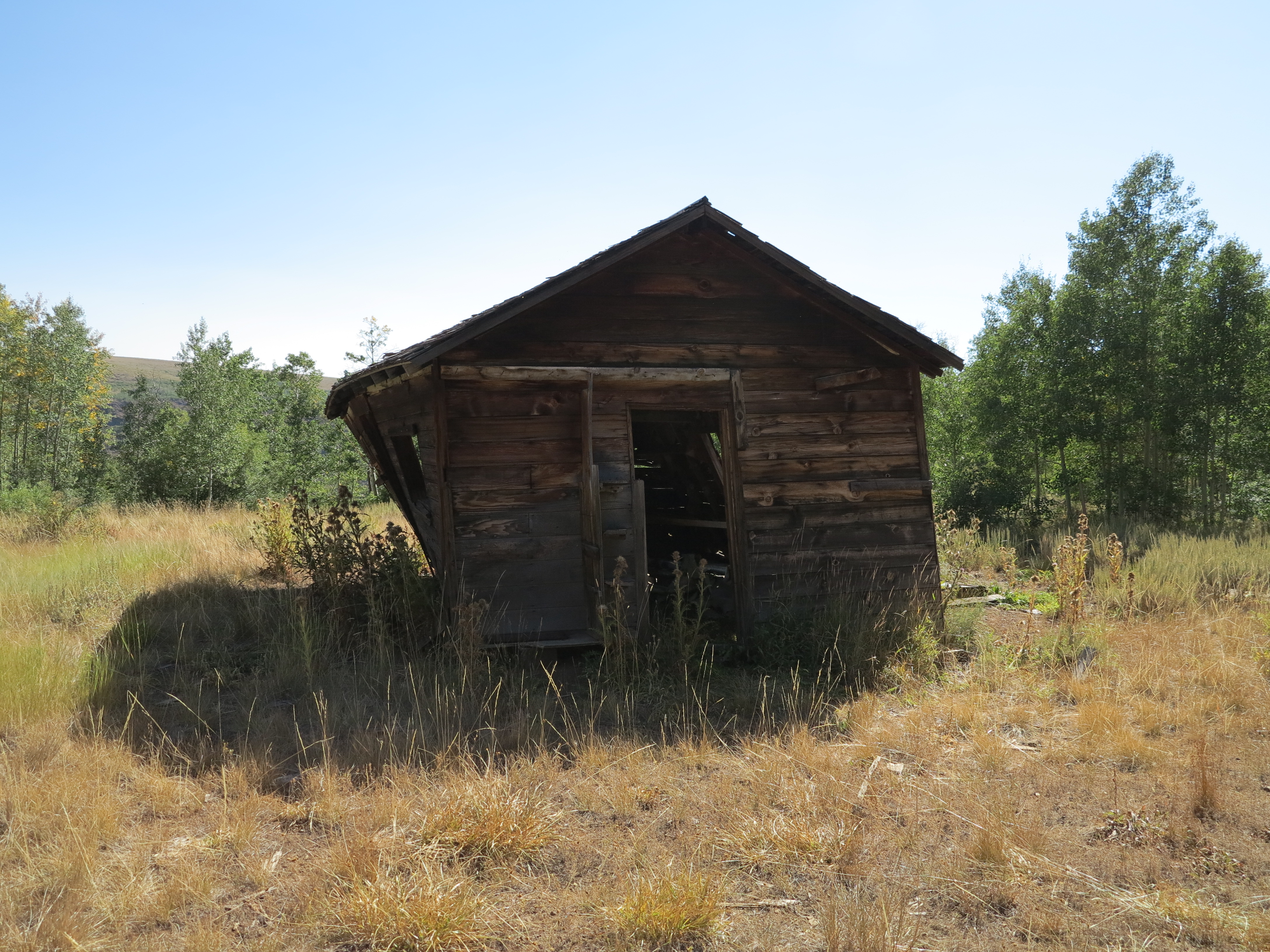
Hunters’ Lodge
The interior. No one dared entering it.

Almost 45 degrees – will fall soon.
We continued on the road for a couple more of miles and found a place where we could see the Little Blitzen Gorge.

Little Blitzen Gorge
Here looking towards the east, towards the Steens Mountain.

Little Blitzen Gorge, looking towards the Steens Mountain
Chris and Doug on the edge.

Chris and Doug on the edge of the canyon
And here is the video of the road we took get to the cabin and the view of the Little Blitzen Gorge. The road got worse and less traveled that farther from the main road we went. You will see on this video some of the rocks, the ruts, including the one time where my little WR250R decided to check the bottom of a rut. But since it is a light machine, it was easy for me to get it out of it. It was a fun road! Of course, it involved chasing Doug for a while, for that extra fun factor…
After we were done with this small road we went to the other side of the north road and checked another road, one we had used in 2010 to come from Diamond to the top of the Mountain, by-passing Frenchglen and much of the north access road.

This road will take you all the way to Diamond (or somewhere near Diamond)
After all was said and done, we decided to go back to the ranch, to our campsite. What does Annie have in store for us for dinner?

Pasta,tomato sauce, sausage, cheese and pesto. It was perfect!
That was another nice day for an adventure ride. We built the fire again, more stories were exchanged, checked the bright stars in the sky, and planned our next day. The plan was simple: go to Fields and fuel up, from there do the Domingo Pass – Rincon Flat – Long Draw – Hawks Valley – Funnel Canyon – Catlow Valley loop.

View of the Long Draw – my favorite road in my favorite loop – Up Next
This is my favorite loop for its roads, views, and isolation. If I happen to fall on a “Ground Hog Day” while riding, this is the loop I would like to be riding when it happens, so I could be riding it day after day.

Wow. That looks like so much fun, but tiring at the same time.
It always amazes me how dry and desolate Eastern Oregon is compared to Western Oregon. It is like you are riding on the moon. Were some of those roads part of the OBDR route?
Yes, it is very dry over there. Although they get their share of rain, and we faced some of that on our last day there – I will post about it after the next post. But yes, most of the time it is really dry and desolate, and I really like it. On the next post I’ll show why… 🙂 And no, none of those roads are part of the OBDR. Route V of the OBDR, the more easterly route going from south to north, goes through a more central part of the state, from Lakeview going past Christmas Valley and from there towards the Seneca area.
Cesar:
Wow ! Thank you for taking us there, to a place which I will probably never see with my own eyes. I have been down 395 to Lakeview and Christmas Valley but where you went you need a WR250, something that i don’t think I could see buying now at this late stage in life.
We used to explore backroads up here when I had my Jeep but I think I have to stick to paved roads for now. Sometimes I wished I could turn the clock back . . .
Looking forward to your next post, and photos
bob
Riding the Wet Coast
Hey Bob,
No need to turn the clock back. You can go all the way from your house to Frenchglen, OR on paved roads (find your way to Burns, OR and from there take 205 south). And that north rim road to the top of the Steens, you can do that on the Strom or on the BMW – it is very smooth. Just go slow and you will be more than fine! Leave the side road adventures for wackos like me.
Cesar
Cesar:
I guess I was fixated on your single track with the rut. If I fell into that with no one else around no one would find me. Very nice scenery there.
I was through Burns and took 395 down to Lakeview and I really liked the area around Lake Abert, then I took 31 back to La Pine
bob
Riding the Wet Coast
Bob,
On the following day, report coming up soon, Christian fell on a deeper rut with the F800GS and it took two of us to get that beast out of it.
Yes, the area around lake Abert is really nice. Hwy 31 is a nice Hwy. But south of Burns towards Frenchglen, you go through the Malheur National Wildlife Refuge, which is nice.
Cesar
Thank you for documenting your adventures for us to share with you. Reading these posts was my inspiration to head to this area with some friends and see it for ourselves. Loved it! Here is my attempt at some brief video highlights
https://www.youtube.com/embed/EwQcMeXk2qs?version=3&rel=1&fs=1&autohide=2&showsearch=0&showinfo=1&iv_load_policy=1&wmode=transparent